Crisis in the Heartland: Climate Challenges in America's Breadbasket
Written on
Chapter 1: The Diverging Landscapes of Kansas
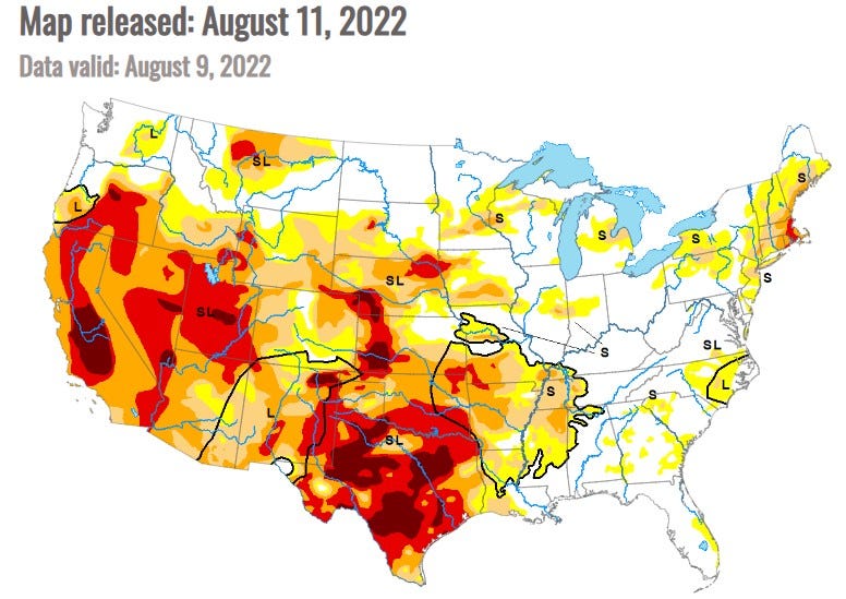
The Oklahoma Panhandle offers a view that might seem endless on a clear day, yet it starkly contrasts with the reality of its agricultural landscape, where 95% of wheat fields between Boise City and Guymon remain fallow due to persistent drought conditions.
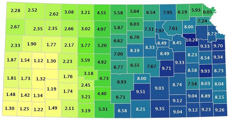
Kansas exhibits a hydrological dichotomy; its eastern regions flourish with greenery, while the west faces desiccation. This stark difference suggests that the ongoing drought in the Southwest is encroaching further eastward.
Now, let’s delve into a critical concern: The Ogallala Aquifer.
Section 1.1: The Ogallala Aquifer’s Significance
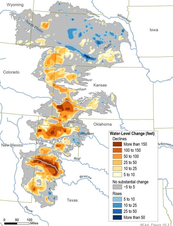
If Lakes Powell and Mead represent the core of the Colorado River crisis, then the Ogallala Aquifer serves as a crucial lifeline for the Great Plains. Identified by a geologist in 1898, this aquifer is among the largest globally and the most significant in the United States. Initially discovered near Ogallala, Nebraska, its comparatively shallow depth allowed early settlers access to vital water supplies. However, large-scale utilization began only in the 1950s with the advent of diesel-powered pumps and the development of center pivot irrigation systems—those circular green patches visible from above at cruising altitude.

Spanning from west-central Texas to South Dakota and lying beneath parts of eight states, the Ogallala Aquifer has seen a dramatic increase in well drilling, particularly in West Texas, where the count surged from 1,166 in 1937 to over 66,000 by 1971. This transformation turned a once-impoverished farming region into a prosperous one, albeit at the cost of severe depletion.
In western Kansas, decades of extraction have caused significant declines in the water table, leading to diminishing yields from wells and, in some cases, total exhaustion.
“The aquifer shrank by more than a foot in 2021; one county in western Kansas only has an estimated ten years of aquifer water left,” reported Progressive Farmer.
Scientific American highlights the severity: “The Ogallala aquifer is being depleted at an annual volume equivalent to the flow of 18 Colorado Rivers. Nature can’t keep up with human demands.”
A USDA report warns that replenishing this vital resource could take over 6,000 years at the current extraction rates, with projections indicating a 70% depletion in just 50 years. While drought is a contributing factor, agriculture consumes 90% of the groundwater, prompting urgent discussions on conservation efforts.
Section 1.2: Understanding the Dry Line
From a meteorological perspective, a dry line signifies the boundary between moist and dry air masses, influencing weather patterns. These lines are particularly evident in thunderstorms across the Great Plains, especially in Texas, Oklahoma, and Kansas.
Since 1979, this dry line has shifted approximately 100 miles eastward, now nearing the 98th meridian.
The following map illustrates the precipitation disparities in Kansas during May 2022, highlighting the contrast between the wetter eastern regions and the arid west.

In western Kansas, wheat predominates as the primary crop, offering some resilience to drought conditions. However, the ongoing shift toward aridity presents challenges for those farming on the “corn side,” where high-yield crops demand substantial water—22 to 30 inches annually. As conditions worsen, farmers may need to adapt by transitioning to hardier crops or rangeland, leading to increased prices for corn and consequently beef.
Chapter 2: The Rising Tides of Conflict
The North American monsoon season has brought significant rainfall to eastern Colorado and western Kansas, but drought conditions persist in southwestern Nebraska, igniting tensions over water resources.
Section 2.1: The Water Conflict Unfolds
In the High Plains, encompassing northeastern Colorado and southwestern Nebraska, drought levels range from moderate to extreme. This region, critical for cattle ranching and crop production, is now a battleground for water rights.
A historic compact allows Nebraska to claim land from Colorado along the South Platte River, which they intend to use for a canal project. Colorado, however, is seeking to secure water resources for the rapidly expanding Denver metropolitan area before Nebraska can commence construction.
Nebraska's proposal allows for the extraction of up to 3,700 gallons of water per second from mid-October to April, with a budget of $500 million allocated for the project. While the South Platte’s groundwater is vital for the dwindling Ogallala aquifer, this initiative would merely divert water downstream.

Section 2.2: The Bigger Picture
Recent drought assessments indicate improvements in regions like South Dakota, although others continue to face severe conditions. Notably, North Dakota has seen relief due to this spring’s “atmospheric river,” significantly enhancing conditions across the northern high plains.
Conclusion: The Uncertain Future of Water Resources
Similar to the megadrought affecting the West, the future of the Ogallala aquifer remains uncertain. Different areas exhibit varying depths, with Nebraska currently experiencing the most significant depletion.
High demand is putting further strain on water supplies, with proposals such as T. Boone Pickens’ ambitious plan to sell groundwater from his Texas land to El Paso, alongside Amarillo’s recent acquisition of water rights to bolster its supply.
As tensions rise and resources dwindle, the question looms: will there be enough water for future generations?
Stay tuned for Part 6 of The Megadrought Series 2022, where we’ll turn our focus to Texas and the ongoing challenges in water management.
Sources:
- “The Next Disaster Coming to the Great Plains” by Lucas Bessire in The Atlantic, 12/26/2021
- “Running Out: In Search of Water on the High Plains” by Lucas Bessire
- “A Free Market Plan to Save the American West from Drought” by Abraham Lustgarten in The Atlantic, March 2016
- Amarillo Globe-News, 7/27/2022
- “The Ogallala Aquifer” in AgFacts as published in Scientific American, 10/08/2020
- “The Ogallala Aquifer: Saving a Vital U.S. Water Resource” by Jane Braxton in Scientific American, 3/1/2009
- “What is a Dry Line, and Why Does it Create Severe Weather?” by Nicolas Shelton on boldmethod.com, 7/17/2021
- “A Nation Divided: Arid/Humid Climate Boundary in U.S. Creeps Eastward” by Sharmon Hall in Scientific American, 4/27/2018